Systems Background
Sensors Demonstrated
You will be guided by Transparent Sky through a viewing of imagery from our WAMICam III system. The demonstration may also include data from one or more of the following sensors:- WAMICam III-250, available TRL-7 product
- WAMICam III-65 prototype
- WAMICam III-120 prototype
- WAMICam II, available (for Lockheed-Martin Stalker only)


Aircraft/UAS
Live demonstrations are currently given using an AirCam twin-engine aircraft with data shared over Starlink.
- A twin-engine AirCam currently carries the WAMICam III-250
Prior recorded collections come from the following aircraft:
- AFRL/DZYNE Ultra UAS (WAMICam III-250)
- Cessna T-210 (All sensors)
- Lockheed-Martin Stalker (WAMICam II)
Today’s demonstration may involve a mixture of data from these craft.
Mission Sequence
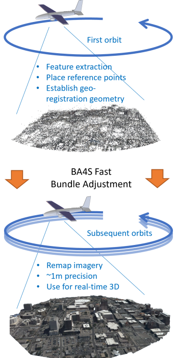
Operations of the WAMICam depends upon whether the system is “free-running”, or if it has had the opportunity to register to terrain. Normal operations involve orbiting an area for an indefinite period of time, observing all activity within a large area of observation. A normal operation will show the following phases:
First Orbit
Imagery is geolocated using inertial sensors and information about the camera, providing imagery projected on the globe in a realistic manner. During this phase, images are registered to each other (for multi-camera systems) using features tracked in the scene and a Transparent Sky-developed algorithm know as Dynamic Homography. Additionally, data is collected for more precise operations.
Bundle Adjustment (BA4S)
Data from the first orbit is precision-aligned using the lightning-fast BA4S algorithm (Bundle Adjustment For Sequences), developed by and licensed from The University of Missouri.
Subsequent Orbits
Transparent Sky’s proprietary R3DR (RedRiver 3D Registration) provides super-stable imagery. Errors are often less than 2m, depending upon terrain elevation maps. Superresolution-enhanced imagery provides detailed viewing of areas under observation.
 

Why It Matters
We can cover and observe an enormous area (up to 70 sq. km.) encompassing entire urban areas such as Khan Younis shown on the left. Patterns of life can be observed. Friends can be separated from foes. Targeting coordinates can be developed.
Additional Features and Functions
3D Models
Transparent Sky’s WAMICam III generates high-quality 3D models, literally “on-the-fly”. These models include:
- Sparse and dense point clouds
- Mesh geometries
- Elevation maps
- Ultra-realistic 3D gaussian splatting fields
Enhancements
Transparent Sky includes all of the code necessary to show these 3D products properly geo-registered in a variety of tools, including custom C++ viewers and the Web-based IntelliFlow viewer above.
WAMICam III also supports advanced functions that can be demonstrated such as:
- Superresolution
- Shadow removal
- Haze removal
Live 3D
Live 3D viewing is a key technology from Transparent Sky. In addition to the legacy method of “3D relighting” where meshes are re-textured. A much more accurate method of live 3D gaussian splatting is under development. Live 3D can provide:
- Much higher precision
- Little/no distracting parallax motion
- Image compression of 1000x or greater
- Response to objects/threats prior to recognizing what they are.

Why It Matters
Detailed Static Intelligence (from “fast” 3D)
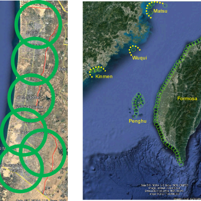
Areas as large as the entire Gaza strip (left) could be covered continuously and provide updated, detailed 3D models of the entire area to plan routes, determine obstacles and hideaway threats, and even determine where engineering is required to repair damage.
Seamless Surveillance of Huge Boundaries and Areas (from “live” 3D)
Live 3D imaging can be used to seamlessly stitch a moving view of the entire battlespace. For example, with a fleet of even a few hundred UAS, it would be possible to create a surveillance barrier 4 miles deep around all populated coasts and outlying islands of Taiwan (right).
Live 3D also permits the use of more UAS at lower altitudes getting them below clouds. Furthermore, lower altitudes can facilitate use of less expensive night vision possibilities such as LWIR and low-light EO cameras. Thus, this is a possible way of achieving detailed all-weather surveillance of massive areas.
Large Area Coverage of Linear Tracks
If demonstration time permits, we will perform a scan of a track as the aircraft returns.
What It Is
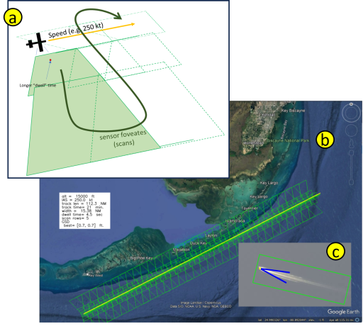
WAMICam III can perform linear scans of very large areas by flying along a ground track while looking out toward the horizon and back (a). An advantage of using WAMI for this function is that each area remains under observation for a much longer time than it would with a traditional ISR sensor, and the width of the area covered can be much greater using WAMICam than other sensors as well.
Why It Matters
Linear track scanning can establish a very wide swath in which items cannot evade detection. An example of the Florida Keys is shown below in which a medium turboprop aircraft could scan a 15-mile wide swath in 45 minutes, detecting all boat traffic within the area. Due to the width of the swath and the possibilty of revisiting frequently, a boat would have a very difficult time escaping detection. Use of AI tools such as WakeNet (c) can provide automated detection of the targets.
This technique can also be used to map large military formations to a level of detail that includes all vehicles such as the Russian armored convoy that threatened Kiev in 2022.
Learn More
We hope you enjoyed our demonstration today. Please feel free to share it with colleagues. You (or they) can reach us with the information below
Contact
Transparent Sky, LLC
Home
director@transparentsky.com
(505) 803-2684
